My buddy Troy and I decided to head up for the day to get some exercise (well, I need the exercise - see below!). It was pretty hot (probably in the 80s), and the trail is fairly long - our intent was to ride out to Horseshoe Lake and back, making it about 19 miles round trip. Troy had done it a couple weeks ago, and liked it, so I wanted to try it.
To get to the trail head, just head straight up Hwy 9 from Saratoga, and the trail starts right where Hwy 9 meets up with Skyline Blvd (Hwy 35).
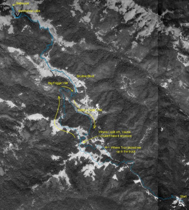
I was doing fine until lunch. We got out to Horseshoe Lake with no problems, and ate (I had peanut butter and honey sandwiches - yumm!). We found a bathroom out there also, and it looks as though you can get there by car, although I don't know why you would - it's really not a very nice lake, more like a big pond.
As soon as we headed back, though, I could start to feel my legs complaining. At first I figured they were just cold after sitting for so long, but as we kept going, they got worse and worse. I kept having to stop and catch my breath and let my legs get some feeling in them again. Eventually I gave up, and took a fireroad out to Skyline Blvd, and waited for Troy to pick me up (thanks Troy).
All in all, it was a good trip, and I really liked the trail, but be warned that it is fairly long (especially if you're not in shape), and coming back is worse than going in. It's pretty much up and down, with some level spots thown in (but not very many). And there's a STEEP hill just before (going in) the junction of Long Ridge trail and Peters Creek trail. I was skidding the whole way down and my brakes got a workout. We decided to take Peters Creek on the way back, 'cause there's no way I could make it up that hill (and I want to see somebody who can!)
Below are some extra files you might want to look at. Too bad I didn't take my camera, because there are some very nice views. Maybe next time.
Satellite view of the area with an overlay of our track (courtesy of my GPS)
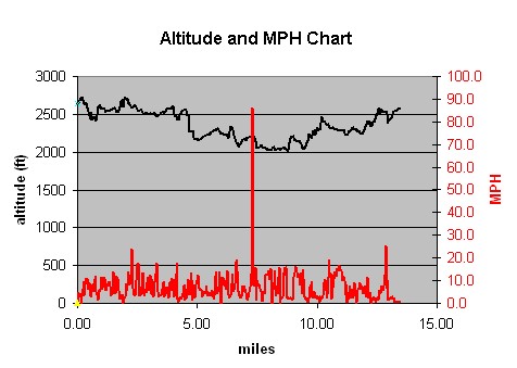
Chart of Altitude and MPH (I don't know where that spike in the MPH came from!)